The Québec maritime Blog

-
International Appalachian Trail on Mt. Blanc in the Réserve faunique de Matane, Gaspésie
Marie-France L'Écuyer/Tourisme Gaspésie
Trekking in Eastern Québec
The wide-open spaces found in the maritime regions of Québec are an ideal natural playground for long-distance hikers. For an exceptional immersive experience, there’s nothing like spending several days trekking through our wilderness areas, in the mountains, forests or tundra, along rivers or along the Estuary and Gulf of St. Lawrence, wearing your hiking boots and with everything you need in your backpack.
Here are a few recommended trekking routes in Bas-Saint-Laurent, Gaspésie, Côte-Nord and the Îles de la Madeleine for the more adventurous among you!
Sentier National (National Hiking Trail)
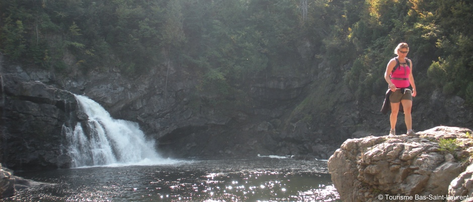
The National Hiking Trail crosses the region of Bas-Saint-Laurent from Trois-Pistoles, along the St. Lawrence, all the way inland to Dégelis, near the outlet of Lake Témiscouata. This 144-km (89-mi.) trail is divided into 12 sections, each of which is 7 km (4 mi.) to 15 km (9 mi.) long and all of which will take you through a variety of environments, including the shoreline of the St. Lawrence, rivers surrounded by majestic cliffs, deer feeding areas and maple groves. The trail crosses Parc national du Lac-Témiscouata, passing by the magnificent Sutherland Falls (considered by some to be the high point of this trek), as well as through a rare white and red pine forest in the Montagne à Fourneau section. Most of the trail is accessible year-round, but outside national park boundaries, it’s best to avoid it during hunting season. Several accommodation options are available to trekkers, including two shelters managed by the organization responsible for the trail.
International Appalachian Trail
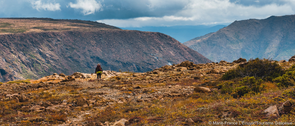
Recognized as the first long-distance hiking route (GR®) in North America, the Québec segment of the International Appalachian Trail (IAT) allows you explore the depths of the forest in Gaspésie while also soaking up unique views from peaks over 1000 metres (3300 feet) high in the Chic-Chocs as well as along the St. Lawrence, the largest estuary in the world. The trail begins in the municipality of Matapédia, near the western end of Chaleur Bay, then winds through the Matapédia Valley to Amqui. It then runs through the Réserve faunique de Matane and Parc national de la Gaspésie before descending back down to the St. Lawrence at Mont-Saint-Pierre and more or less following the coast all the way to Cap-Gaspé at the tip of Forillon National Park, over a total distance of about 650 km (400 mi.). Since there are many ways to access the trail, you can trek shorter sections of it to suit your interests and the time you have available. The wildlife reserve and national parks offer rustic shelters and campsites where you can the night; elsewhere along the trail, SIA Québec manages a network of shelters and tents platforms that you can book online.
Uapishka (Groulx) Mountains
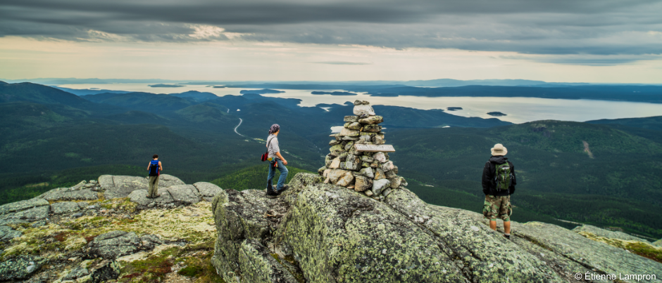
In Côte-Nord, the Uapishka (Groulx) Mountains offer a complete change of scenery. Accessible via Route 389, which stretches from Baie-Comeau to Fermont, these mountains are home to boreal and alpine tundra vegetation along with a multitude of northern wildlife species. The Station Uapishka, located at Km 336 on Route 389, offers lodging and activities, including hiking on six groomed and marked trails (three available in the summer and three in the winter), with trailheads located between Km 335 and Km 365. You can also trek across the mountains between the Provencher trail (which takes you to the top of Mt. Provencher) and the Jauffret trail (which takes you to the top of Mt. Jauffret). Please note, however, that there’s no signposting between these two trails, which means you’ll need excellent orienteering skills, a compass and a GPS to undertake this trek.
Sentiers Entre Vents et Marées trails
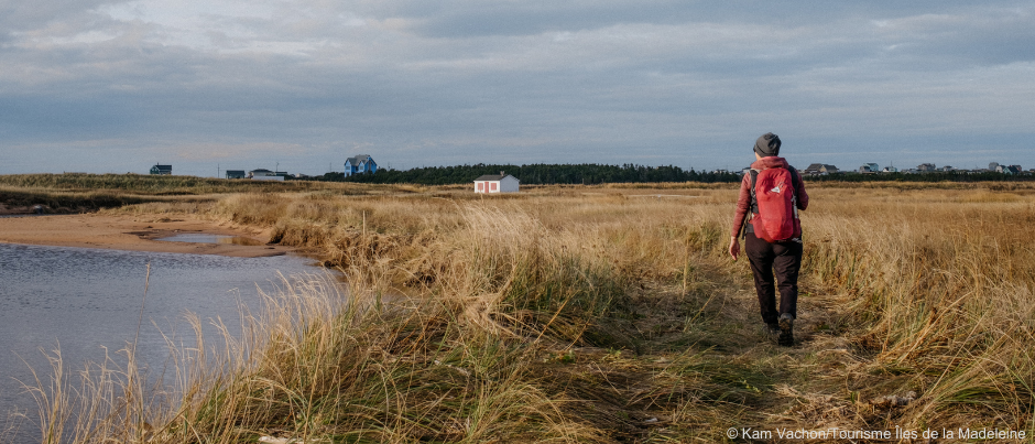
You can also go trekking in the Îles de la Madeleine now, thanks to the Sentiers Entre Vents et Marées trails, which were inspired by the Camino de Santiago. Totalling nearly 235 km (145 mi.), these trails are divided into 13 sections that range in length from 9 km (6 mi.) to 28 km (18 mi.), allowing you to explore the archipelago at your own pace and from every angle, via dunes, beaches and hills. Pick up a Passeport du Louvoyeur (Wanderer’s Passport) and have it stamped for each section of the trail you complete as well as by the various businesses you visit along the way, so you’ll have a record of your adventures. In addition, a network of lodging establishments along the trails has been certified Bienvenue Randonneurs (which means they welcome trekkers), including Auberge La Salicorne, Château Madelinot and La reCréation. All of these establishments will offer you services tailored to your specific needs as a trekker.
Safety tips
Here are a few things to consider when planning your trek: the long-distance trails in our regions go through isolated areas, which will provide a welcome sense of solitude; however, this also means you’ll be fairly cut off from the outside world. If you’re lucky, you may have cell reception from the top of mountains… To be safe, be sure to travel with a beacon or satellite messaging device to be able to report your location in case of an emergency. In addition, be sure to leave your itinerary with someone you trust. You should also bring a water filter or water purification device. Before your trip, test your backpack by filling it with what you plan to take with you and then wearing it for a few hours to make sure you can carry it in real-life conditions. And don’t forget to review the Leave No Trace principles so you can apply them during your trek!
Are you intrigued by these treks? Take the time to prepare properly for your trip, then strap on your backpack and come and soak up the magnificent natural landscapes in our regions!
If you liked this article, you might also like...
Author Jean-Pascal Côté

A certified translator and avid outdoorsman, Jean-Pascal Côté works as a freelance writer and translator in Bas-Saint-Laurent, the region where he was born. He regularly escapes his daily life by going road biking, cycle touring or cyclocross racing, skiing in the mountains of Bas-Saint-Laurent or Western Canada, or sea kayaking on the St. Lawrence River. He is constantly dreaming up new travel plans. He also blogs (on an admittedly irregular basis) about his cycle touring adventures.
(0) comment