The Québec maritime Blog

-
Parc national du Bic, Bas-Saint-Laurent
Mathieu Dupuis
Discover Hidden-Gem Trails in Our National Parks
The maritime regions of Québec are home to many national parks. These vast territories in Bas-Saint-Laurent, Gaspésie and Côte-Nord offer lots of popular hiking trails as well as some hidden gems that can be discovered from June to October. Follow the guide!
Bas-Saint-Laurent
Îlet au Flacon loop
Parc national du Bic
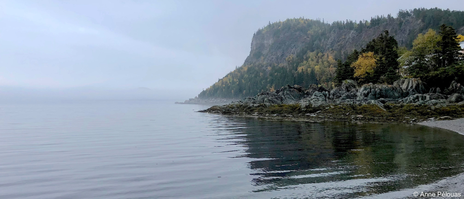
A jewel in the crown of the Bas-Saint-Laurent region, this park stretching along the St. Lawrence has several very popular trails. Located just outside Saint-Fabien-sur-Mer at the western end of the park, Îlet au Flacon offers a loop trail that’s a little more off the beaten track. From Anse à Capelans, you’ll walk along a beautiful beach before turning left. Begin your tour of this peninsula jutting out into the St. Lawrence by walking along a rocky shoreline. At the western tip, you can admire a lovely cove (Anse à Mercier). Continue your walk along the rocks and then on the beach. Keep in mind that this hike is only accessible at low tide!
- Trailhead: via Chemin de la Mer E. in Saint-Fabien-sur-Mer
- Length of trail: 2 km (1.2 mi.)
- Duration: 1 hour
- Level of difficulty: easy
- When to go: in the spring, summer or fall
Sutherland trail
Parc national du Lac-Témiscouata
Bordering one of the largest bodies of water in Québec, this park offers 11 trails through the forest and the Notre-Dame Mountains. The Sutherland trail begins at the end of Chemin Sutherland and winds along Lac Rond for 1 km (0.6 mi.). It will then plunge you into the forest until it reaches a 180-metre (590-foot) boardwalk that will take you across a marsh teeming with aquatic life, a perfect place to watch birds! The highlight of this hike is your walk up a stream to a series of waterfalls in the middle of the forest. Dip your toes into the cool water in the summer or admire the colourful leaves in the fall.
- Trailhead: Sutherland parking lot
- Length of trail: 6 km (3.7 mi.) round trip
- Duration: 2.5 hours (round trip)
- Level of difficulty: easy
- When to go: May to October
Gaspésie
Mont-Olivine loop
Parc national de la Gaspésie
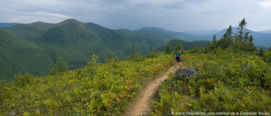
Of the many hiking trails in this park, Mont-Olivine is in a class of its own. The small mountain of the same name looks out over its bigger sisters nearby, from Mt. Albert and Mt. Blanche-Lamontagne to Mt. Ernest-Laforce. At an elevation of 670 metres (2200 feet), Mt. Olivine is an outstanding spot to observe the Chic-Choc Mountains. An old mining road will take you gently up through a forest of balsam fir and white birch. After 1 km (0.6 mi.), it narrows and climbs steadily to a split in the trail. Turn right to begin the loop to the bare summit and soak up an amazing view before descending to the edge of the Diable River. You’ll then skirt Lac du Diable before returning to the split in the trail and then to the trailhead.
- Trailhead: Ruisseau-Isabelle parking lot on Route du Parc (Route 299)
- Length of trail: 12 km (7.5 mi.)
- Duration: 3.5 to 4 hours
- Level of difficulty: intermediate to difficult
- When to go: in the summer or fall (or on snowshoes in the winter!)
La Vallée and le Portage trails
Forillon National Park
Located at the tip of the Gaspé Peninsula, this park gives you the opportunity to hike along the coast of the Gulf of St. Lawrence as well as inland. Both the La Vallée and Le Portage trails bisect the park and will take you from the north side of the peninsula to the south (and vice-versa). Set off from L’Anse-au-Griffon on the La Vallée trail, which is also open to bikes and horses, and follow the river south for 4.6 km (2.9 mi.). Next, keep heading in the same direction on the Le Portage trail for 6 km (3.7 mi.) through woods and fields that are most beautiful in the summer or fall. Unless you’ve left a second car in the parking lot on the south side of the peninsula, you’ll then need to head back to L’Anse-au-Griffon: this time, follow the Le Portage trail all the way, which will take you along the other side of the river for 4 km (2.5 mi.).
- Trailhead: L’Anse-au-Griffon parking lot
- Length of trail: 9.2 km (5.7 mi.) for La Vallée (round trip), 20 km (12.4 mi.) for Le Portage (round trip)
- Duration: 2.5 hours for La Vallée; 5 to 6 hours for Le Portage
- Level of difficulty: easy to intermediate
- When to go: late May to mid-October
Les Mousses trail
Parc national de l'Île-Bonaventure-et-du-Rocher-Percé
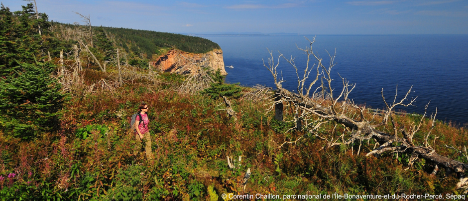
Located 3 km (1.9 mi.) off the coast of Percé, Bonaventure Island is a wildlife and nature paradise that’s home to an impressive northern gannet colony. The Les Mousses trail (the most northerly) begins at Pointe à Butler, on the western side of the island. This narrow and unobtrusive trail climbs slightly and then winds for 1.9 km through moss- and lichen-covered slopes before reaching the cliffs. On the eastern side of the island, you can admire a cove (Anse Chatouilleuse, which literally means “ticklish cove”) from a lookout. The trail then runs along the shoreline from the top of the cliffs, offering beautiful views of the sea before reaching Pointe à Margaulx, where you can observe the world’s most accessible northern gannet colony. You’ll then have to retrace your steps or follow any of the island’s three other trails back to Pointe à Butler.
- Trailhead: Pointe à Butler, via a boat trip from Percé
- Length of trail: 7 km (4.3 mi.) round trip
- Duration: 2.5 hours
- Level of difficulty: easy to intermediate
- When to go: mid-May to mid-October
Côte-Nord
Le Fjord trail
Parc national du Fjord-du-Saguenay
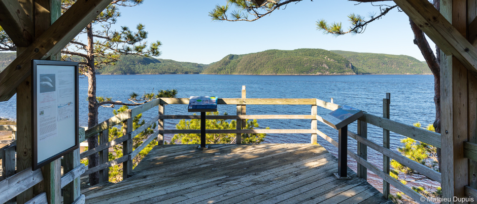
Backpacking enthusiasts love Le Fjord, even though this 42-km (26-mi.) trail offers a rollercoaster hiking experience. However, you can also just hike a section of this trail in a day. The most popular leads to the Halte du Béluga lookout in the Baie-Sainte-Catherine sector, which is a great place to observe these small white whales. On the other hand, the central part of the trail is less frequented. From Anse Creuse to Cap de la Boule, panoramic views of the Saguenay Fjord will unfold before your eyes as you climb rocky capes and hike around coves while crossing through forested areas. The trail first descends, losing a few hundred metres in elevation over 2 km (1.2 mi.) of hiking until you reach the Anse-Creuse hut, which clings to the rocks and offers a magnificent view of the fjord. The trail will then take you up and down over and over again, almost always within sight of the water. A rustic campground is found at Pointe-à-la-Passe-Pierre on a small peninsula. Belugas can often be sighted here. A series of climbs awaits you in the direction of Cap de la Boule, your final destination… unless you have enough energy to keep climbing to the Cap-de-la-Boule hut where you can spend the night!
- Trailhead: Anse-Creuse parking lot (Rang Saint-Joseph) or Cap-de-la-Boule parking lot (Rang Saint-Georges) in Sacré-Coeur
- Length of trail: 13.2 km (8.2 mi.) one way
- Duration: 7 to 8 hours
- Level of difficulty: difficult
- When to go: mid-May to mid-October (or on snowshoes in the winter!)
- Luggage transportation and vehicle transfer service available
Les Télégraphes trail
Parc national d'Anticosti
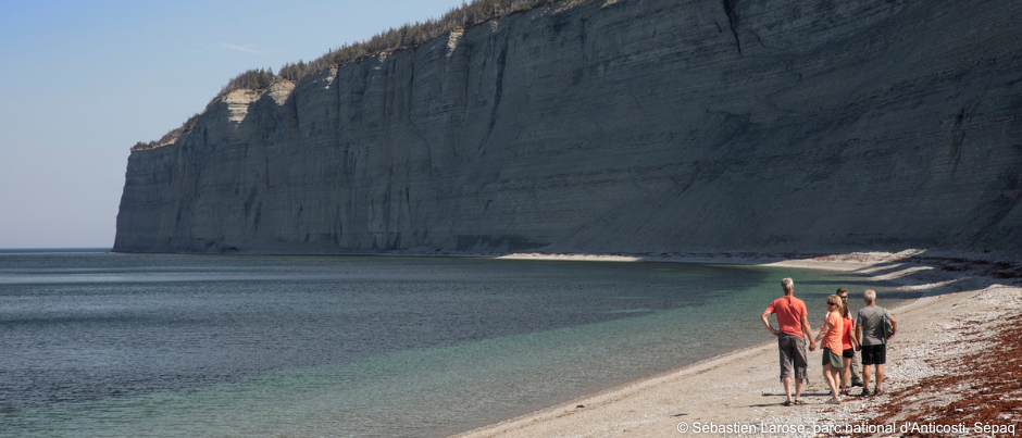
Emerging from the waters of the Gulf of St. Lawrence, Anticosti will enchant you. Wild by nature, this island is partially protected by a national park. Hikers can enjoy 125 km (78 mi.) of trails in the central area of the park and can also go for strolls along the shore. At the eastern end of the park, Baie de la Tour is bordered by a pebble beach that’s over 2 km (1.2 mi.) long. The Les Télégraphes trail invites you to admire this majestic area from above. A good 400-metre (1310-foot) climb through the forest will lead you to a split in the trail. From there, a 3.1-km loop will transport you between sea and mountains. If you head left, you’ll soon come to three lookouts over the Gulf of St. Lawrence and the magnificent cliffs bordering the bay. At over 50 metres (165 feet) above sea level, the views are amazing! The trail continues with a long descent through the forest. Be sure to go for a short stroll along the beach on your way back and you may be lucky enough to spot a seal’s head or a whale’s tail…!
- Trailhead: Baie de la Tour parking lot, located at Km 152 on Route Transanticostienne, 2.75 hours from Port-Menier
- Length of trail: 5 km (3.1 mi.)
- Duration: 2 hours
- Level of difficulty: intermediate
- When to go: June 20 to late August
Samuel trail
Mingan Archipelago National Park Reserve
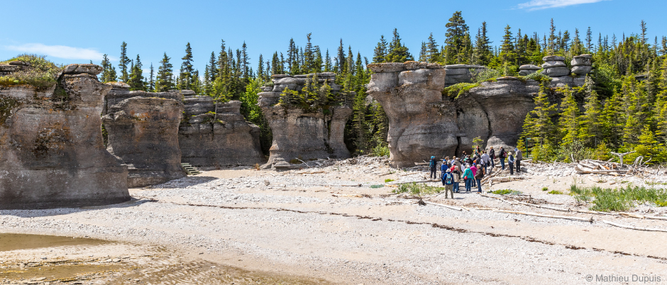
Off the coast of Longue-Pointe-de-Mingan and Havre-Saint-Pierre, the Mingan Archipelago fascinates visitors with its giant limestone monoliths sculpted by the sea, colonies of migratory birds and rare flowers. About 80 km (50 mi.) of trails are spread over nine islands in the archipelago. The Samuel trail, on Niapiskau, begins at Anse des Bonnes Femmes, a great place to admire the island’s strangely shaped monoliths. Running along the shoreline, it circles the Barachois à Dye and part of Anse à Loups Marins before entering the forest. The contrast between the maritime and forest environments is striking: the mosses found in the woods will transport you into a magical world from which you’ll emerge at Anse du Noroît. If you stay in the rustic campground located here, you’ll have lots of time to discover beautiful fossils along the shoreline and explore the small island forest at your leisure.
- Trailhead: Niapiskau Island, via a maritime shuttle from Longue-Pointe-de-Mingan or Havre-Saint-Pierre
- Length of trail: 8.8 km (5.5 mi.)
- Duration: 3 to 4 hours
- Level of difficulty: easy to intermediate
- When to go: June to September
Less frequented than others, these eight hidden-gem trails are all invitations to take the time to enjoy nature and breathe in the fresh sea air or the scents of the forest in the national parks of Eastern Québec!
If you liked this article, you might also like...
Author Anne Pélouas
Anne Pélouas, a native of France, has been a journalist in Québec for over three decades. She was the Canadian correspondent for the prestigious French daily newspaper Le Monde for 20 years, while also working as a freelance journalist specializing in tourism, the outdoors and the art of living for Québec publications, a niche she maintains with passion. She has travelled throughout the maritime regions of Québec and continues to be enchanted by the landscapes found here as well as by her memorable encounters and the unusual activities on offer, all of which provide rich fodder for her stories.
(0) comment